For more than a century, utilities have relied on human eyesight to identify specific trees that pose a danger to conductors, but the results often fall short. Now, cloud computing and artificial intelligence (AI) offer the hope of greater speed and accuracy for utility vegetation-management efforts. Such advances couldn’t be more timely because, as California’s recent wildfires have shown, our transmission systems are at even greater risk.
The hazards of depending solely on human inspection to manage tree growth and removal within utility rights-of-way have been seen in multiple events over the last two decades. The massive North American power outage in August 2003 was started when a drooping conductor came in contact with what a later report called “overgrown trees.” And California’s utility regulators have targeted electric-utility vegetation-management practices in the wake of devastating wildfires over the past several years.
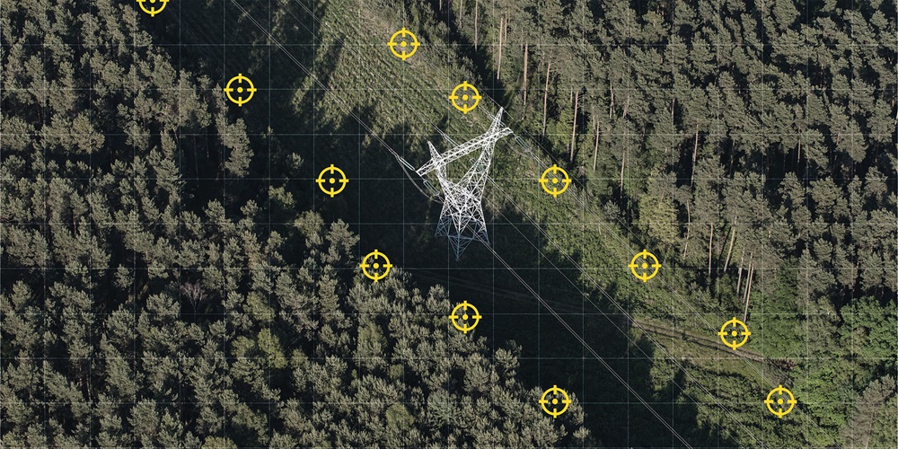
This is not to discount the challenges utilities and other transmission-system operators face. They may have thousands of miles of lines to monitor that pass through regions only accessible by air. This is why many utilities are turning to a technology called light detection and ranging, abbreviated as lidar. It’s similar to radar except it uses pulses of infrared light, rather than radio waves, to develop precise 3D images of terrain and vegetation.
“It gives the utility situational context as to what the features are around those conductors,” said Nick Ferguson, vice president of strategy and business development for Enview, a San Francisco company that uses AI to speed the interpretation of lidar images. “Lidar is able to tell the utility if any of those conductors are violating clearance requirements.”
Turning lidar data into usable images manually is extremely time- and labor-intensive. A single flyover map can take up to six or seven months—and tens to hundreds of staffers—to process, Ferguson said. That’s where cloud-based AI, such as the technology Enview has developed, can help.
“We shorten the time scale to a few days by using AI technology, specifically machine vision, combined with large-scale cloud computing,” Ferguson said.
The process of gathering the raw data isn’t that much different than what’s used for more traditional aerial photography. Lidar transmitters and receivers are attached to the wing of a plane or drone. But the result provided to the utility is much more than just a nice aerial photograph. The digital images delivered to a user’s desktop can be turned and studied from multiple angles that resemble 3D computer-aided design models. Enview’s AI calls out potentially hazardous trees and other risky conditions on a one-by-one basis so ground crews know where to go for visual inspections and possible tree removals.
“The resulting output is a detailed assessment of everywhere on a utility corridor the vegetation is encroaching electrical clearance distances and therefore poses a reliability or safety risk,” Ferguson said, adding that the AI also understands that transmission lines are dynamic and can move based on a number of factors. “The system will account for the sag and sway of a conductor that occurs due to changes in electrical load and weather.”
The speed and detail are enabled by a process that breaks the raw lidar data into individual packets or tiles with each representing a small portion of the total image file. These tiles are analyzed based on data Enview personnel have used to train the AI to recognize what each line structure and topographical feature might look like in different settings. Using a cloud platform, such as Amazon Web Services, the company is able to draw on the computing power of thousands of central processing units and graphics processing units in parallel to create the models they deliver to customers.
This approach also can highlight other potential risks along utility rights-of-way. Lidar systems can see through trees all the way down to the ground. This capability can help utilities understand where geohazards, such as landslides or riverbank erosion, might be putting tower foundations at risk. And it also can identify areas where third-party activity, such as road and building construction, might encroach onto rights of way.
Utility adoption of AI-powered lidar is still in its early stages. However, Ferguson expects adoption and capabilities will ramp up quickly, enabling lineworkers to access images from tablets in the field almost as soon as lidar data is received by an overhead aircraft.
“I anticipate the power of the cloud will be brought to edge-use devices that workers in the field could make use of,” Ferguson said. “Having lidar in an edge-computing device will bring lidar into near real time.”
About The Author

ROSS has covered building and energy technologies and electric-utility business issues for more than 25 years. Contact him at [email protected].